Plans & Projects Under Review
The City of Fresno makes every effort to encourage public participation, while simultaneously informing the public of projects that are under review. The following is a list of projects currently under review and reports prepared on behalf of the City.
Fresno Yosemite International Airport – Airport Traffic Control Tower Relocation Project
Project Location: The Proposed Project is located on Airport property at 5055 East Andersen Avenue, Fresno, CA 93727. The existing Airport Traffic Control Tower (ATCT) is located on a 2.25-acre site northwest of the passenger terminal and adjacent to the Aircraft Rescue and Fire Fighting (ARFF) building. Site coordinates are 36° 46’ 24.34” N and 119° 43’ 19.00” W. The Assessor’s Parcel Number (APN) is 494-071-78.
Project Description: The City, as owner and operator of the Fresno Yosemite International Airport (FAT or Airport), proposes to replace the existing ATCT at the Airport. The existing ATCT includes the Terminal Radar Approach Control Facilities (TRACON), which would be relocated with the ATCT. The replacement ATCT would be constructed about 150-200 feet south of the existing ATCT. The existing ATCT would be demolished following construction of the replacement ATCT.
The Proposed Project includes the following components:
- Construction of a new ATCT facility, including TRACON, with an estimated building footprint of 13,000 square feet (sq ft) and tower height of up to 190 feet.
- Installation of new equipment in the replacement ATCT.
- Extension of utility services to the replacement ATCT.
- Reconstruction of the existing parking lot to provide adequate parking for the replacement ATCT.
- Demolition of the existing ATCT facility, including TRACON.
Who do I contact for more information?
For additional information, please contact Francisco Partida at [email protected].
Contact Phillip Siegrist, Planning Manager via e-mail [email protected] or by phone 559-621-8061 to request electronic copies or to schedule an appointment to view documents.
FAT ATCT Final EIR – certified December 18, 2025
Appendix A FAT ATCT NOP Scoping Comments
Appendix B FAT ATCT AQ Emissions
Appendix C FAT ATCT Cultural Tribal Resources
Appendix D FAT ATCT Phase I ESA
Appendix E FAT ATCT Notice of Availability and Response to Comments
Appendix F FAT ATCT Mitigation Monitoring and Reporting Program
FAT ATCT Public Draft EIR (CEQA)
FAT ATCT Draft EIR
FAT ATCT DEIR NOA
Appendix A FAT ATCT NOP Scoping Comments
Appendix B FAT ATCT AQ Emissions
Appendix C FAT ATCT Cultural Tribal Resources
Appendix D FAT ATCT Phase I ESA
Comment Period
September 10, 2025 – October 27, 2025
[email protected]
Notice of Preparation
FAT ATCT Environmental Assessment (NEPA)
Appendix A FAT Airport Layout Plan
Appendix B FAT Regulatory Setting
Appendix C FAT U.S. Fish and Wildlife Service Information for Planning and Consultation
Appendix D FAT Section 106 Consultation Materials
Appendix E FAT Final Section 4(F) Evaluation
Appendix F FAT Phase 1 Environmental Site Assessment
Appendix G FAT Detailed Air Quality Emissions Data
Appendix H FAT Public Involvement
FAT No Significant Impact and Record of Decision
FAT ATCT Public Draft EA
Comment Period
June 22, 2025 – August 6, 2025
Central Southeast Area Specific Plan
Central Southeast Specific Plan Public Draft Environmental Assessment
The Public Draft of the Central Southeast Specific Plan Environmental Assessment is now ready for Public Review. The public comment period is from December 19, 2025, to January 19, 2026. The Environmental Assessment can be downloaded below in the Project Document Section. The Specific Plan and Environmental Assessment is tentatively scheduled to be considered by Planning Commission and City Council in January and February 2026.
How to Comment
Send via email to [email protected] and [email protected] or mail to:
Long-Range Planning
2600 Fresno Street, Room 3065
Fresno, CA 93721
Project Area
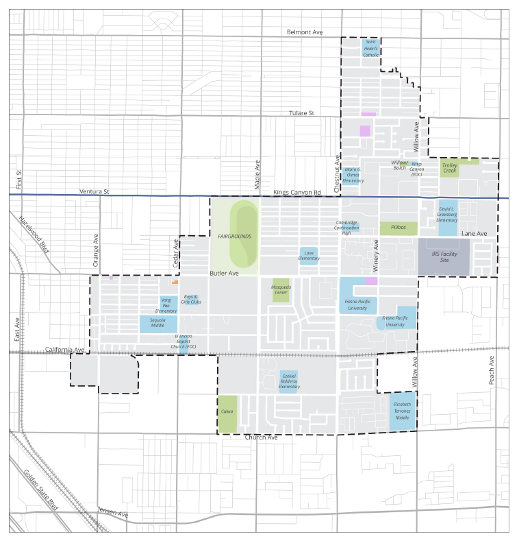
The Central Southeast Specific Plan area covers over 2,067 acres (3.4 square miles) just east and southeast of downtown, bounded by Belmont Avenue to the north, Fourth Street to the west, Church Avenue to the south, and Peach Avenue to the east. This diverse area is characterized by a mix of suburban housing developments, industrial uses, public facilities, and vacant land.
Why is the Specific Plan important?
The Central Southeast Specific Plan offers a special opportunity to help shape the future of southeast Fresno – including the area’s economic vitality, transportation network, parks, and neighborhood character. Based on feedback from the community and elected officials, the area could benefit from infrastructure and mobility improvements, increased access to parks and open space, development of vacant lots, and recommendations to revitalize key commercial corridors such as Ventura/Cesar Chavez Boulevard. The Specific Plan will help:
- Shape the places we live, work, shop, and play
- Guide the public services, infrastructure, and investments in the area
- Guide the types and forms of new development in Southeast Fresno
- Establish clear priorities to better guide investment
Who do I contact for more information?
For more information call Juan Lara at the City of Fresno [email protected] or call (559) 621-8039
Project Documents
Recirculated Initial Study/Mitigated Negative Declaration for Central Southeast Specific Plan
Notice of Intent to File Recirculated Initial Study/Mitigated Negative Declaration
Subsequent Mitigated Negative Declaration for Central Southeast Specific Plan
Notice of Intent to File Mitigated Negative Declaration
Documents Incorporated by Reference:
Central Southeast Specific Plan – Public Review Draft – 2025
Central Southeast Specific Plan – Public Review Draft – 2021
Central Southeast Specific Plan Existing Conditions Report
Factsheet
Central Southeast Specific Plan Initiation Report
Workshop Material
Below you will find the presentations and Community Workshop summary’s for the workshops to date. If you would like to host a mini-workshop please email Drew Wilson at [email protected].
Central Southeast Area Specific Plan Community Workshop 1 Summary
Central Southeast Area Specific Plan Community Workshop 1 PowerPoint
Central Southeast Area Specific Plan Community Workshop 2 PowerPoint
Initiation Report
A fundamental step in the Central Southeast Specific Plan process is the initiation of the Plan’s Draft Guiding Principles and the Proposed Land Use Map. The initiation process includes the Fresno City Council’s approval of the Proposed Land Use Map that will allow the project team to begin the Environmental Assessment. A report has been drafted to summaries how the development of the Guiding Principles and Proposed Land Use Map. The Central Southeast Specific Plan Initiation Report can be found below in the Project Documents section.
Farmland Preservation Program
Policy RC-9-c of the Fresno General Plan directs the City of Fresno to create a Farmland Preservation Program. The adoption of a Farmland Preservation Ordinance will direct how the City of Fresno implements the program.
Policy RC-9-c
Farmland Preservation Program
In coordination with regional partners or independently, establish a Farmland Preservation Program. When Prime Farmland, Unique Farmland, or Farmland of Statewide Importance is converted to urban uses outside City limits, this program would require that the developer of such a project mitigate the loss of such farmland consistent with the requirements of CEQA. The Farmland Preservation Program shall provide several mitigation options that may include, but are not limited to the following: Restrictive Covenants or Deeds, In Lieu Fees, Mitigation Banks, Fee Title Acquisition, Conservation Easements, Land Use Regulation, or any other mitigation method that is in compliance with the requirements of CEQA. The Farmland Preservation Program may be modeled after some or all of the programs described by the California Council of Land Trusts.
Program Environmental Impact Report for Revisions to the City of Fresno General Plan
Notice of Preparation of a Program Environmental Impact Report for Revisions to the City of Fresno General Plan with Scoping Meeting Information
Public Review Period for the NOP
The NOP is being circulated for public review and comment for a 30‑day period beginning February 27, 2026. Comments in response to the NOP will be accepted until 5:00 p.m. on March 30, 2026. Please submit your written comments to Mr. Lara and include your name, address, and phone number and/or email address so that we may contact you for clarification, if necessary.
Contact:
Juan Lara, Planner III
Planning and Development
2600 Fresno Street, 3rd Floor, Room 3065
Fresno, CA 93721
(559) 621-8039
[email protected]
Scoping Meeting
The City held a public scoping meeting to inform interested parties about the Program Environmental Impact Report for Revisions to the City of Fresno General Plan and to provide agencies and the public with an opportunity to provide comments on the scope and content of the Program Environmental Impact Report. The meeting time and location was as follows
Fresno City Hall
City Council Chambers
2600 Fresno Street
Fresno, CA 93721
Date: March 5, 2026
Time: 5:00 p.m.
Brownfields Program
Southeast Development Area Specific Plan
PROJECT AREA
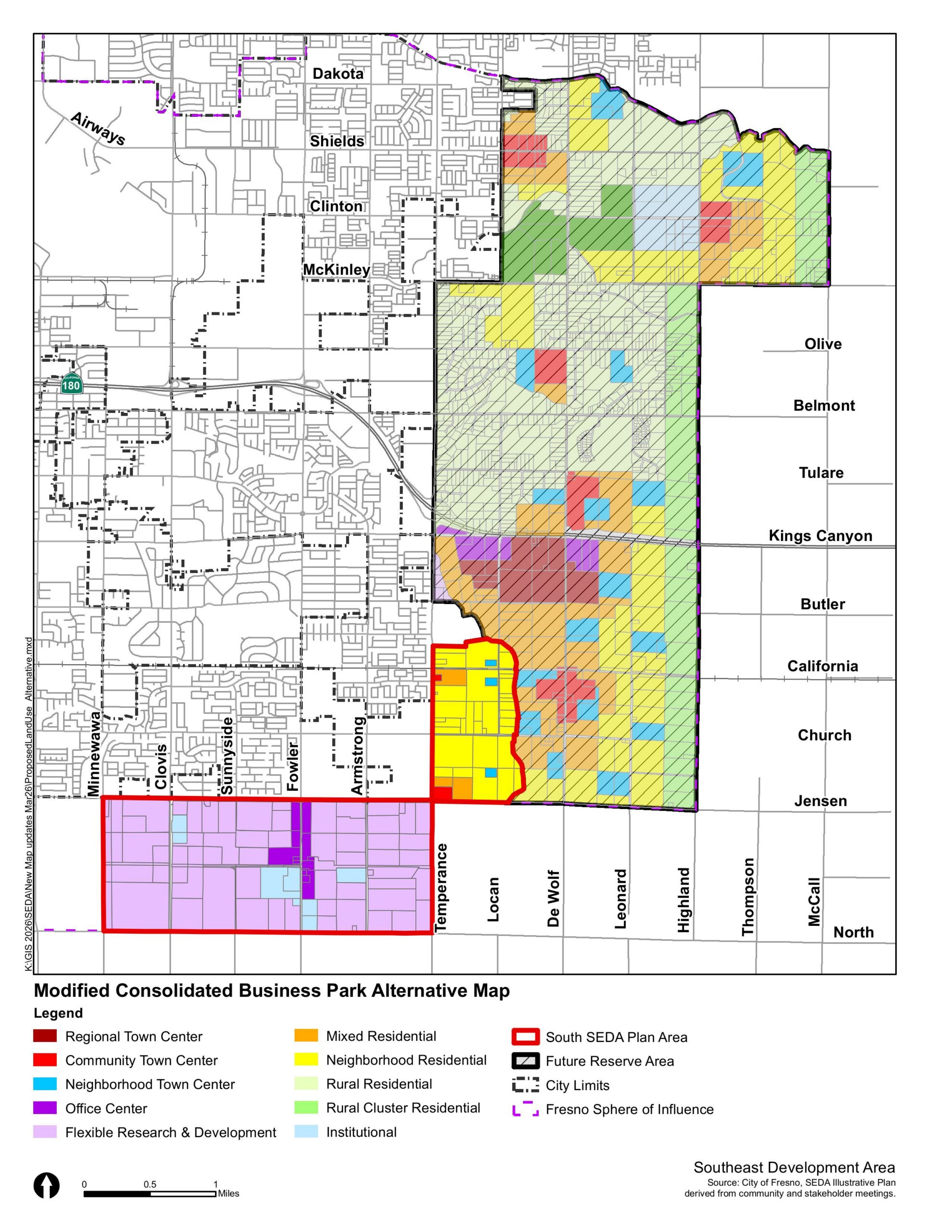
The regional location of the nearly 9,000-acre SEDA Specific Plan Area is in the southeast portion of the City, in Fresno County (County), California as shown in the map here. The Plan Area is bounded on the north by the Gould Canal, on the east by McCall and Highland Avenues, on the south by Jensen and North Avenues, and on the West by Locan, Temperance, and Minnewawa Avenues.
UPDATES
The SEDA Specific Plan and Environmental Impact Report will be presented to the Planning Commission on the following date:
Planning Commission
Wednesday, August 19th, 6:00pm
Fresno City Hall, Council Chamber
2600 Fresno Street, Fresno, CA 93721
Please continue to visit this website for updates in addition to visiting https://fresno.legistar.com/Departments.aspx to access upcoming City meetings and agendas.
UPDATED PROJECT MATERIALS
SEDA FEIR
- July 29, 2026 Findings of Fact and Statement of Overriding Considerations
- June 2, 2025 Final EIR (Response to Comments and Errata)
- February 7, 2025 Recirculated Draft
PAST EVENTS
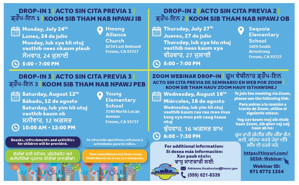
SUMMER 2023 DROP-IN MATERIALS:
SEDA Summer Drop-In Zoom Webinar Recording
Proposed Land Use Map
Land Use Descriptions
EIR Handout
EIR Executive Summary
Comment Card
Comments Received During Public Comment Period
Comments Received During Recirculated Public Comment Period
Translated documents are available upon request
- Public Meeting 1 – Click here for the Public Meeting 1 Presentation
- Public Meeting 2 – Click here for the Public Meeting 2 Recording
- Public Meeting 3 – Click here for the Public Comment Brochure
- Click here for the Public Meeting 3 Presentation
- Click here for the Public Meeting 3 Recording
- June 14 Listening Session:
– Click here for the Listening Session Agenda
– Click here for the Listening Session Audio Recording
– Click here for the written summary of Listening Session input
PREVIOUS PROJECT MATERIALS
- Public Facilities Financing Options Report – May 2025
- Draft SEDA Specific Plan 2025
- Draft SEDA Specific Plan 2023
- Housing Market Demand Analysis – April 2025
- Recirculation – Notice of Availability February 2025
- Public Comments – 2025 Recirculation
CONTACT INFORMATION
For more information, please contact [email protected] or (559) 621-8339
Para más información, comuníquese con [email protected]
.lYog Xav Paub Ntxiv, Xa Email ntawv hauv vassab lossis Hu [email protected]
ਹੋਰ ਜਾਣਕਾਰੀ ਲਈ, ਈਮੇਲ ਜਾਂ ਕਾਲ [email protected]
Papé Materials Handling Project
(Development Permit Application No. P22-04027)
Project Description:
The proposed project includes the construction of a two-story, 52,600 square-foot commercial building for rental, sale, repair and maintenance of construction and warehouse equipment. The proposed commercial building includes office space for staff, and warehousing and shop areas. The proposed project would also include the construction of a separate 6,000 square-foot vehicle wash and storage building along the site’s northern boundary, employee and customer parking, landscaped areas, and equipment storage racks and a stormwater retention basin along the eastern portion of the site.
To facilitate the future development of the subject property, the proposed project would provide, as required, dedications for public street rights-of-way, as well as the construction of public facilities and infrastructure in accordance with the standards, specifications, and policies of the City of Fresno.
Project Location:
The proposed project is located at 4254 South Cedar Avenue, on approximately 11.75 acres, and approximately 680 feet northeast of the intersection of East Malaga Avenue and South Cedar Avenue, in Fresno, California. Site Latitude: 36.673219°, Site Longitude: –119.752433°. Mount Diablo Base & Meridian, NW quarter of Section 36, Township 14 South, Range 20 East (Assessor’s Parcel Number [APN]: 330-03-184).
Project Entitlements:
Development Permit Application No. P22-04027, which proposes the construction of a two-story, 52,600 square-foot commercial building for rental, sale, repair and maintenance of construction and warehouse equipment.
Who do I contact for more information?
For additional information, please contact Thomas Veatch at (559) 621-8076 or via email at [email protected].
Notice of Preparation
Comment Period
November 17, 2023 – December 18, 2023
Scoping Meeting: November 2, 2021
The CEQA process encourages comments and questions from the public throughout the planning process. Pursuant to Section 15083 of the CEQA Guidelines, a Public Scoping Meeting will be held to solicit public comments on the scope and content of the EIR. A public scoping meeting for this project will be conducted on Thursday, December 7, 2023, at a meeting room in City Hall (2600 Fresno St, Fresno, Ca 93721) on the 2nd floor, Room 2165 N, as well as on Zoom. The webinar information is provided below:
By Phone at: 1 (669) 900 9128
Thomas Veatch –Planner
City of Fresno – Planning and Development Department
2600 Fresno Street, Room 3043
Fresno, CA 93721 (559) 621-8076
[email protected]