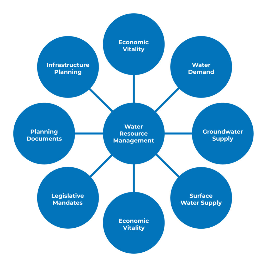
Water Resource Management
The City of Fresno actively plans, develops, and manages its water resources for the optimum benefit of the community. While there are many factors that contribute to water resources management decisions, those most prominent are the following:
Water Demand
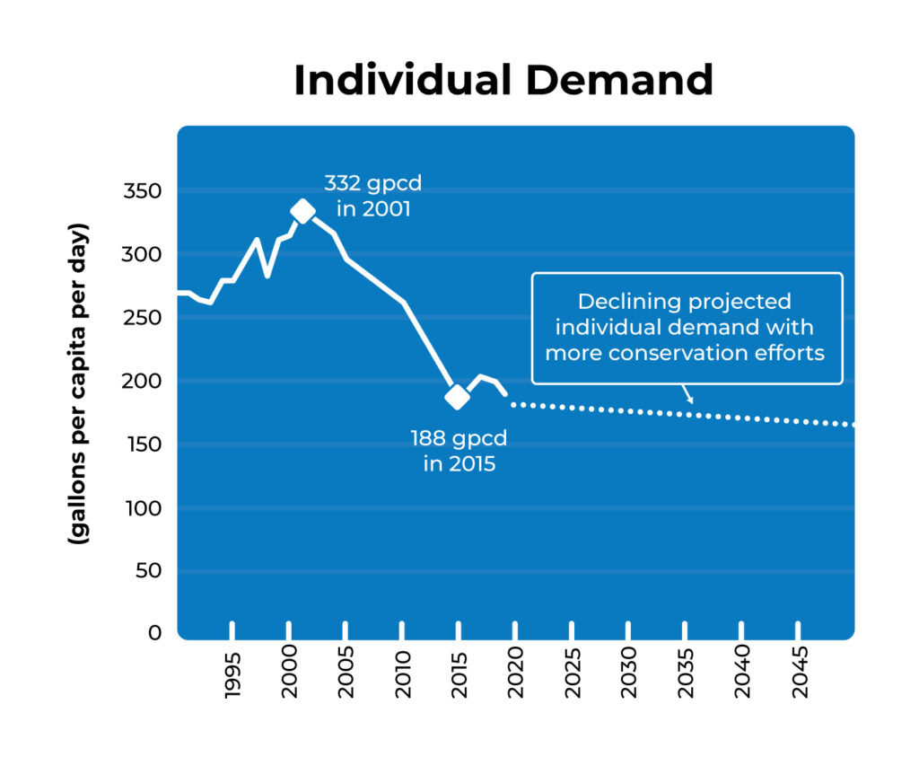
Individual Water Demand
Historical per person water use per day was quite high compared to current usage. Individual water usage increased from 269 gallons per capita per day (gpcd) in 1990 to a peak of 332 gpcd in 2001. However, to conserve and protect the underground aquifer and comply with ever more stringent state standards, the City began implementing various water conservation measures. The most significant water conservation measure was the implementation of the Single-Family Metering Program between 2008 and 2012, which included the installation of water meters on each individual property and incentivized conservation through the volumetric purchase of water rather than the historic flat rate purchase. As the State continues mandating stricter conservation standards, individual water demand is expected to continue dropping into the future.
Citywide Water Demand
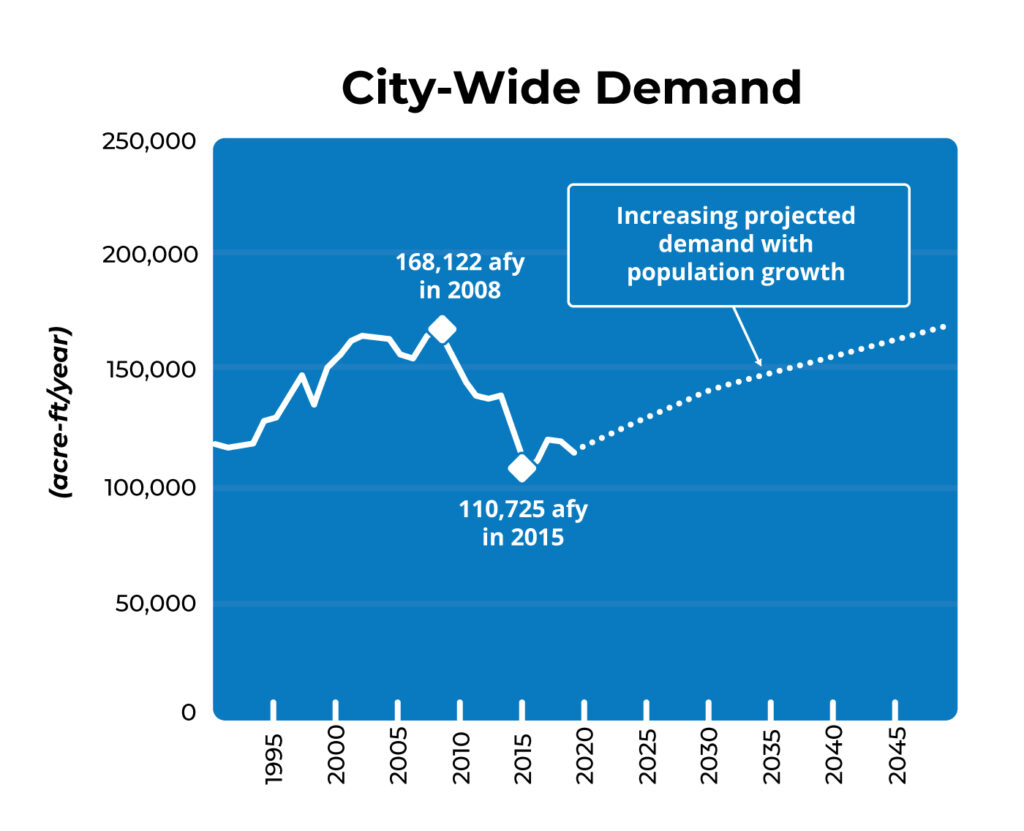
Citywide Water Demand
The substantial reduction in individual water usage following completion of the residential meter installation project, combined with state-mandated drought restrictions and other water conservation strategies, resulted in City-wide reduction in water demand between 2008 and 2015. However, as the City’s population continues to grow, so will the water demand. It will be several years before we again reach our maximum City-wide water demand that first peaked in 2008, but the City continues planning to build and maintain infrastructure to best use our water resources to reliably and cost-effectively deliver water to our community.
Groundwater Supply
Groundwater Basin
The City overlies the Kings Subbasin , which is part of the greater San Joaquin Valley Groundwater Basin. There are two primary aquifers from which the City draws its groundwater:
Unconfined Aquifer
The upper several hundred feet within the Kings subbasin generally consists of highly permeable, coarse-grained deposits, which generally allow for highly productive wells. The City’s planned recharge activities focus on improving groundwater levels in the unconfined aquifer. However, the unconfined aquifer also contains many legacy contaminant plumes. The City has received and continues to pursue legal actions against responsible parties to secure court awards or defendant settlements from polluters to treat impacted groundwater, allowing for its continued use as a primary drinking water source.
Confined Aquifer
A laterally extensive clay layer is located at an average depth of approximately 250 feet below the ground surface. Below this clay layer exists the confined aquifer. Although the clay layer helps protect the water from any surface contamination, it also prevents recharge activities from reaching the confined aquifer.
Groundwater Levels
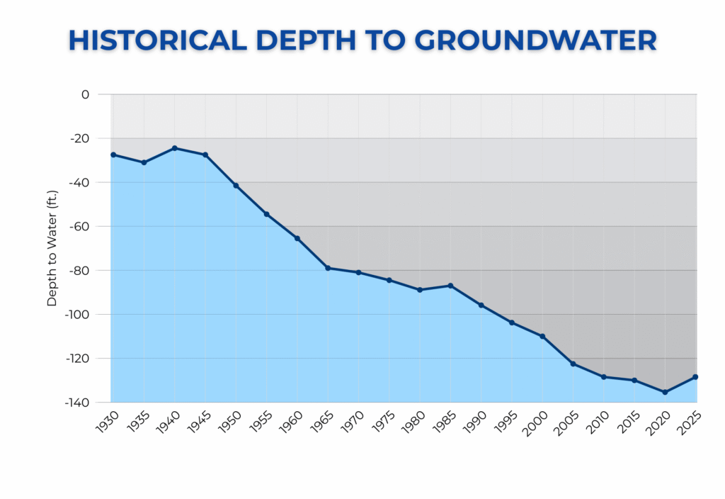
Groundwater levels beneath the City were relatively shallow at 25 feet below ground surface in 1940 prior to the start of World War II. After the war, the City began growing at a rapid rate. From 1946 to 1969, groundwater levels declined at a rate of 2.4 feet per year.
In the 1970s, the City opened Leaky Acres , a 200-acre recharge facility, in an attempt to slow or reverse the decline in groundwater levels. While water levels declined at a slower rate, the City continued to rely on the underground aquifer for decades.
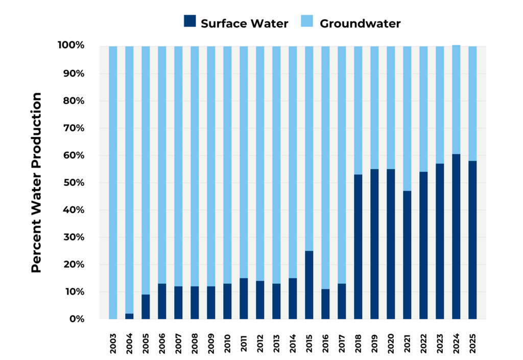
Rates of decline slowed further starting in 2004 when the Northeast Surface Water Treatment Facility (NESWTF) commenced operations and have started to rebound in the last few years following the startup of the Southeast Surface Water Treatment Facility (SESWTF)in 2018. With a greater use of surface water and a renewed focus on groundwater recharge, the City hopes to return the groundwater levels to what they were 60 to 80 years ago.
Surface Water Supply
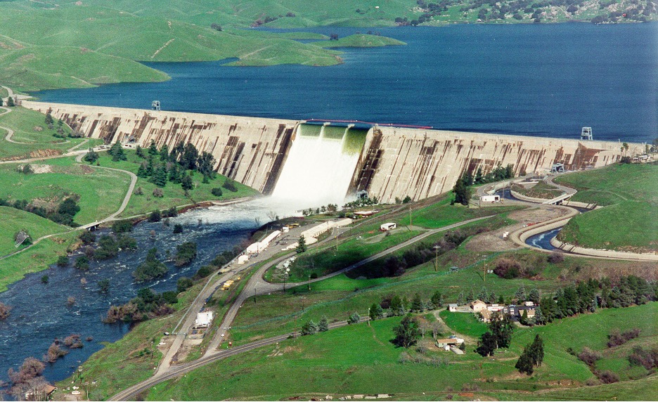
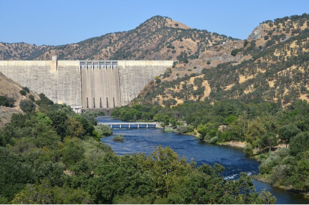
The City of Fresno receives surface water from the San Joaquin River and Kings River water systems. Both surface water sources are of good quality but vary in quantity year-to-year based on the Sierra Nevada Mountain snowpack and annual precipitation. In dry years, the supply may be drastically reduced due to drought conditions and water supply contract obligations to senior water rights holders. Surface water is either treated at the City’s three surface water treatment plants or delivered to the City’s groundwater recharge facilities.
San Joaquin River
The United States Bureau of Reclamation (USBR) oversees diversions from the San Joaquin River through the Friant-Kern Canal of the Central Valley Project (CVP). The City receives USBR Class 1 water from Millerton Lake, which is generally a dependable water supply but does fluctuate in allocation depending on snowpack and reservoir levels. This water is delivered through the Friant-Kern Canal Pipeline to the Northeast Surface Water Treatment Facility (NESWTF).
Kings River
Fresno Irrigation District (FID) has a Kings River water supply entitlement based on the river’s mean daily flow. The City and FID have an agreement by which the City receives a percentage of FID’s entitlement. The water is held in the Pine Flat reservoir, then diverted to City facilities through multiple FID canals and the Kings River Pipeline to the Southeast Surface Water Treatment Facility (SESWTF).
Drought Resiliency
Conjunctive Use of Groundwater & Surface Water
The City of Fresno was historically a 100% groundwater system until 2004, with the startup of the Northeast Surface Water Treatment Facility (NESWTF). With the addition of the T-3 Surface Water Treatment Facility (T3SWTF) in 2015 and the Southeast Surface Water Treatment Facility (SESWTF) in 2018, the City’s water production has become more balanced between groundwater and surface water. As the City continues exploring expansion of the surface water treatment facilities, the City gains greater flexibility with the conjunctive use of surface water and groundwater (i.e. using either water source when most advantageous to the City).
Drought Resiliency
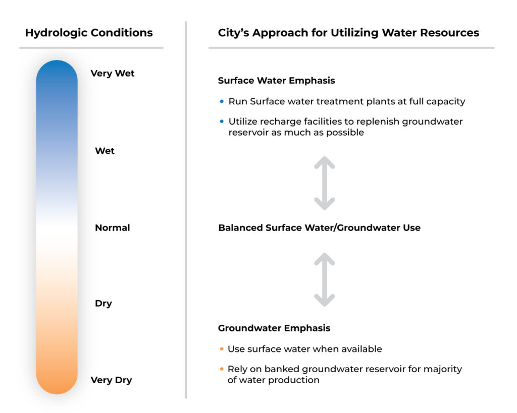
With the City’s ability to use either groundwater or surface water, the City’s approach to utilizing water resources will be adaptive based on the hydrologic conditions. In wet or very wet years, the City will utilize more surface water than groundwater as the drinking water source and utilize recharge facilities and replenish the groundwater reservoir as much as possible. In dry or very dry years, the City will rely on the banked groundwater reservoir for most of the drinking water production. The ability to build up the groundwater reservoir during wet years then later use the groundwater reservoir freely during drought conditions makes the City’s water system drought resilient, with the City able to meet residential and commercial water demands regardless of the hydrologic conditions.
Legislative Mandates
Sustainable Groundwater Management Act (SGMA)
The primary legislative mandate pertaining to water resources management is the Sustainable Groundwater Management Act of 2014 (SGMA), signed into law as a three-bill legislative package. SGMA defines sustainable groundwater management as the management of groundwater supplies in a manner that can be maintained during the planning and implementation horizon (approximately 50 years) without causing undesirable results such as:
- The significant and unreasonable chronic lowering of groundwater levels
- Reduction of groundwater storage
- Seawater intrusion
- Degraded water quality
- Land subsidence
- Depletion of interconnected surface waters
SGMA empowers local agencies to form Groundwater Sustainability Agencies (GSAs) to manage basins sustainably and requires those GSAs to adopt Groundwater Sustainability Plans (GSPs) for crucial groundwater basins in California.
The City of Fresno is a member of the North Kings Groundwater Sustainability Agency (NKGSA), which was formed for the purpose of developing and implementing the GSP for the critically over-drafted northern portion of the Kings Subbasin. The NKGSA is one of seven GSAs within the Kings Groundwater Subbasin.
The City continues to work with regional and statewide partners to ensure our precious groundwater supply is available for current and future generations.
Urban Water Management Plan
California Water Code mandates that urban water suppliers, such as the City of Fresno, prepare Urban Water Management Plans (UWMPs) every five years. Each UWMP communicates how the supplier will ensure adequate water supply availability to meet existing and future water needs. The City of Fresno UWMP is one of several planning documents that the City prepares to plan investments in water supply infrastructure.
Planning Documents
The City of Fresno regularly produces three types of documents that pertain to water resources management.
General Plan
While not focused on water resources management, the City of Fresno General Plan provides a framework around which the Department of Public Utilities (DPU) can plan future water needs. DPU works with the Planning and Development Department to identify areas of growth where new services are needed, as well as identify areas that are undergoing changes that may need modified services.
Metropolitan Water Resources Management Plan
As the primary long-range water resources planning document, the Metropolitan Water Resources Management Plan (Metro Plan) sets the vision, priorities, strategies, and initiatives for the City’s water management and infrastructure investments. The Metro Plan analyzes water supply versus demand, both in the present and projected into the future, suggests potential investments and alternatives to improve reliability and control costs, then provides an implementation and funding plan to make the necessary investments.
Rehabilitation & Replacement Master Plans
Rehabilitation & Replacement (R&R) Master Plans tend to focus on a specific system, analyzing the current condition, the need for renewal and replacement, and potential hurdles as the system ages. One such plan is the Drinking Water infrastructure Renewal and Replacement Plan.
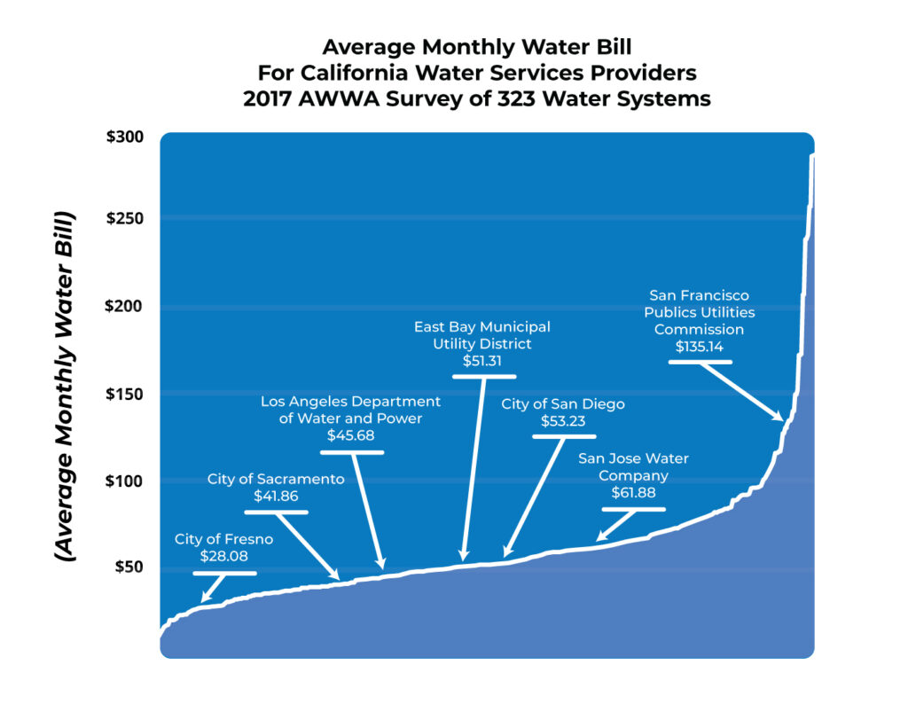
Economic Vitality
Along with its central location in the Central Valley and low cost of living, the City attracts residents due to the affordability of the water resources as compared to other major California cities. A 2017 survey of major and minor water providers across the state identified that the average monthly water bill for City of Fresno water customers was significantly lower than for California’s other major cities.