For questions about the Southeast Development Area, call: 3-1-1
or visit the SEDA Project Page listed below
Understanding SEDA and South SEDA
The City of Fresno is reviewing a long-range plan for the southeast side of the city. This page explains what the plan is, what its first phase includes, and how the City decides whether to approve it. It focuses on the plan itself and the environmental review now under way.
What is SEDA?
The Southeast Development Area, or SEDA, is a long-range plan for about 9,000 acres on the southeast edge of Fresno. This area has been considered Fresno’s growth area since the 1950s, and is what planners call Fresno’s Sphere of Influence. The SEDA Specific Plan sets out how the area could grow over the coming decades, including where homes, jobs, parks, roads, and utilities could go. Many areas in Fresno have Specific Plans, which are detailed blueprints that guide future growth in that particular part of the city.
What is South SEDA?
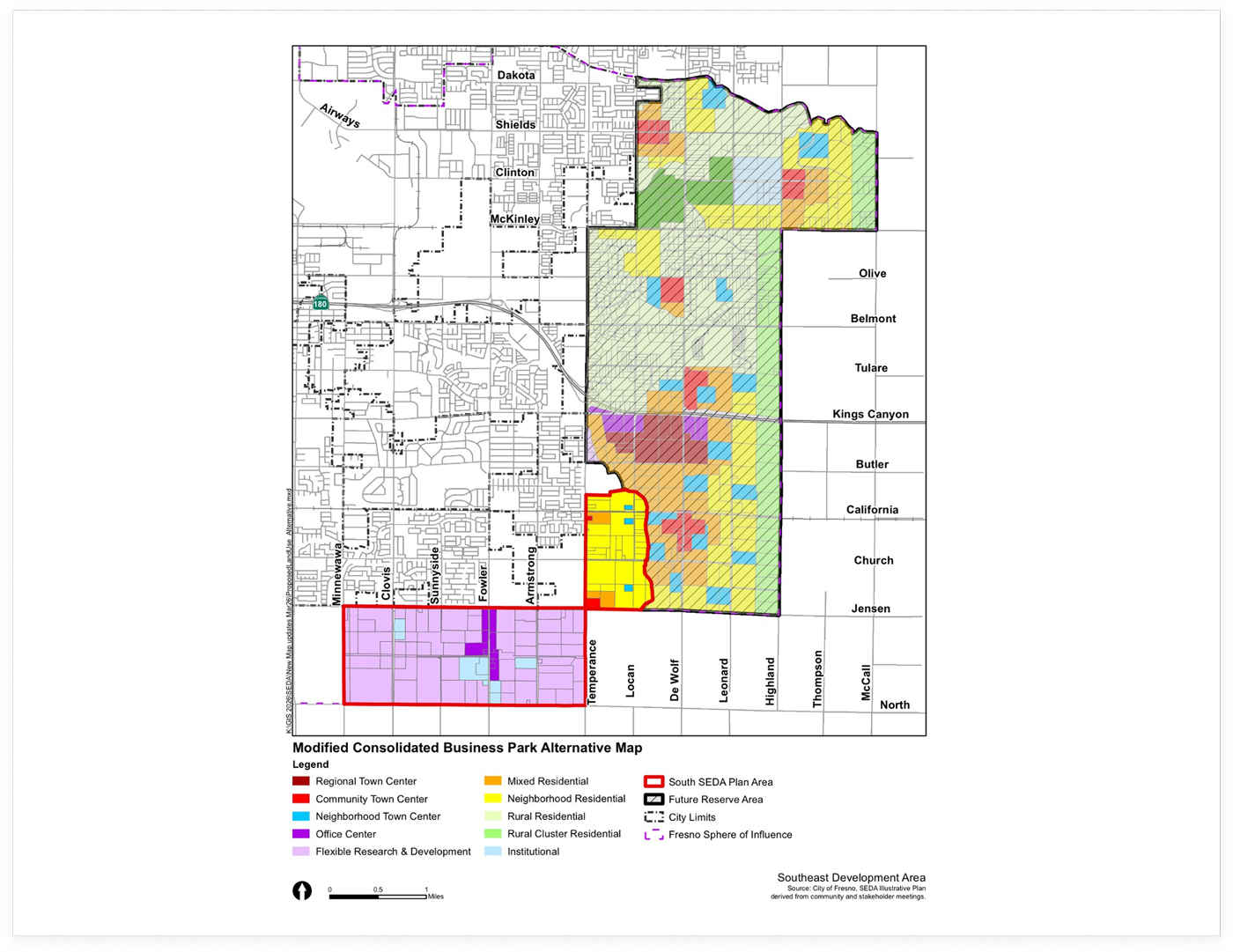
South SEDA is the proposed first phase of that larger area. It covers about 2,000 acres closest to the roads, water, and sewer that already exist. The majority of South SEDA is planned for Flexible Research and Development, a high-skilled job center. A smaller portion is planned for residential housing. It is the only part of SEDA where development could occur in the next few years. The rest of the area is held in reserve, and growth there could not begin until most of South SEDA is built and a supplemental environmental review is done.

What is a Specific Plan?
A Specific Plan is a planning tool allowed under California law. It takes the goals of the city’s General Plan and turns them into detailed rules for one area, covering land uses, street and block layouts, infrastructure, design standards, and the order in which growth can happen. Adopting a Specific Plan does not build anything on its own. It sets the framework that future projects would have to follow.
What is the environmental review?
Before the City can decide on the plan, state law requires it to study the plan’s possible effects on the environment. That study is called an Environmental Impact Report, or EIR, and it is required under the California Environmental Quality Act, known as CEQA. The EIR looks at topics such as traffic, air quality, farmland, water, and noise, and it identifies ways to avoid or reduce effects. The EIR goes through a public review period, and the decision-makers must review and certify it before they can act on the plan.
What are the Planning Commission and City
Council voting on?
1
Planning Commission recommendation
The Planning Commission holds a public hearing and makes a
recommendation. It votes on whether to recommend that the City Council
certify the EIR and adopt the SEDA Specific Plan.
2
City Council decision
The City Council makes the final decision. It holds its own public hearing
and votes on whether to certify the EIR and adopt the Specific Plan.
Upcoming votes are about the Specific Plan and its EIR. They are not approvals of individual construction projects. Future projects within South SEDA would still need their own permits and reviews, and are expected to take years before new development could occur.

How to take part
Both the Planning Commission and the City Council hearings are open to the public, and residents and business owners can comment at each one. You can also read the Specific Plan and the EIR in full on the City’s project page.
The Planning Commission considers the plan on August 19, 2026, with City Council action to follow.
Questions and Answers

What is being decided right now?
The Planning Commission is being asked to recommend, and the City Council will later decide, whether to adopt the SEDA Specific Plan and certify its environmental review.
Does adopting the plan mean construction starts right away?
No. Adopting the plan sets the framework for the area. Individual projects would still need their own permits and approvals before anything is built. New development is still years away.
Can the public weigh in?
Yes. There are public hearings at both the Planning Commission and the City Council, and there is a public review period for the environmental report. For more specific dates and times, please reference the SEDA Project Page.
What is the difference between SEDA and South SEDA?
SEDA is the full 9,000-acre area. South SEDA is the roughly 2,000-acre first phase. As proposed, South SEDA is the only area where development could first begin.
What happens after the votes?
If the Specific Plan is adopted, infrastructure planning for South SEDA would begin. For development to occur following appropriate infrastructure planning, private developments would begin the annexation process to change their portion of the land from County to City. Any expansion beyond South SEDA would come later, and could not begin until most of South SEDA is built and occupied and appropriate studies and actions are taken for the next area.
Where can I read the plan and the environmental report?
You can read everything on the City’s Planning project page, which stays up to date and holds the plan, the
environmental report, and all appendices.